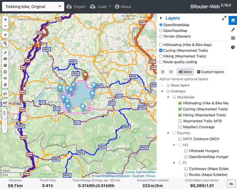
There is a wide range of tools for planning cycling and hiking tours – komoot, Outdooractive and whatever else they are called! But not everyone wants to have to create another user account. Because most of the tools usually don’t work without registration.
Not only for this reason, I would like to briefly introduce the online planning tool BRouter-Web.
BRouter is perhaps already known to outdoor enthusiasts in connection with an app such as Locus Map Pro, in which routes can be calculated via BRouter.
BRouter-Web is an online application, so planning tours is done in the browser.
- 1st link: BRouter-Web
- 2nd link: BRouter-Web
BRouter-Web can be used "out-of-the-box" – even tour planning novices can get started after a few settings and create their first bike tour or hike, export it as a GPX-file and transfer it to the navigation device.
The most important options can be found in the upper right corner under the "layer icon" (see figure):
- OSM map type
- Hillshading
- Waymarked trails for biking and hiking

BRouter-Web – waymarked trails help planning
I consider the marked routes for biking and hiking are one of the highlights. They can be displayed as separate layers. Their course can be used wonderfully as a planning template.
Do you want to plan a round trip in your favourite mountain area or a long-distance hike through the Pyrenees? BRouter provides the perfect basis.
Planning starts via the pencil icon in the left bar. With a few clicks, a route is drawn along the default, exported as a GPX file and pushed onto the navigation device. And if the route calculated by BRouter doesn’t quite fit, the route can be optimized by moving individual sections with the mouse.
I have already used BRouter files on several Garmin GPSMAP and Garmin Edge devices, the Hammerhead Karoo 2 or the TwoNav Cross – when mountain biking or hiking. On the GPSMAP, the tours created in this way can be found under "Saved Tracks", on the Edge under "Saved Courses". On the other GPS devices mentioned, they are available as routes.
Another great feature is the loading of tours. Using the corresponding icon at the top of the page, a tour can be imported as a GPX file – for example, a popular bike path or a long-distance hike like the Sentiero Italia – and used as an additional basis for planning.
But BRouter-Web can do even more. For example, customizing the routing profile is possible. For example, the option "stick_to_cycleroutes" can be activated so that the route calculated by the routing engine always runs along a bicycle route.
With a little playing around you can discover one or the other useful function!
All in all, BRouter-Web is a powerful tool for planning your next bike tour or hike – very uncomplicated without registration or membership and free of charge! In addition, the most important functions are quickly learned!
For me, BRouter has now almost completely replaced all other tools for planning hiking and cycling tours!
Able to Export Custom POI